
Jesus carrying the cross, by
Raphael, 1516
The
Via Dolorosa (Latin for
Way of Grief or
Way of Suffering) is a street, in two parts, within the
Old City of Jerusalem, held to be the path that
Jesus walked, carrying his cross, on the way to his
crucifixion. The current route has been established since the
18th century, replacing various earlier versions.
[1] It is today marked by nine
Stations of the Cross; there have been fourteen stations since the late 15th century,
[1] with the remaining five stations being inside the
Church of the Holy Sepulchre. The route is a place of
Christian pilgrimage.
History
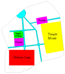
The main roads - the cardines (north-south) and decumani (east-west) - in Aelia Capitolina. The Via Dolorosa is the northern decumanus
The Via Dolorosa is the modern remnant of one of the two main east-west routes (
Decumanus Maximus) through
Aelia Capitolina, as built by
Hadrian. Standard Roman city design places the main east-west road through the middle of the city, but the presence of the
Temple Mount in the middle of this position required Hadrian's planners to add an extra east-west road at its north. In addition to the usual central north-south road (
cardo), which in Jerusalem headed straight up the western hill, a second major north-south road was added down the line of the
Tyropoeon Valley; these two cardines converge near the
Damascus Gate, close to the Via Dolorosa. If the Via Dolorosa had continued west in a straight line across the two routes, it would have formed a triangular
block too narrow to construct standard buildings; the decumanus (now the Via Dolorosa) west of the Cardo was constructed south of its eastern portion, creating the discontinuity in the road still present today.
The first reports of a pilgrimage route corresponding to the Biblical events dates from the
Byzantine era; during that time, a
Holy Thursday procession started from the top of the
Mount of Olives, stopped in
Gethsemane, entered the Old City at the Lion's Gate, and followed approximately the current route to the Church of the Holy Sepulchre;
[2] however, there were no actual stops during the route along the Via Dolorosa itself.
[1] By the 8th century, however, the route went via the western hill instead; starting at Gethsemene, it continued to the alleged
House of Caiaphas on
Mount Zion, then to
Hagia Sophia (viewed as the site of the
Praetorium), and finally to the Church of the Holy Sepulchre.
[1]
During the
Middle Ages, the
Roman Catholics of Jerusalem split into two factions, one controlling the churches on the western hill, the other the churches on the eastern hill; they each supported the route which took pilgrims past the churches the faction in question controlled,
[1] one arguing that the Roman Governor's mansion (
Praetorium) was on Mount Zion (where they had churches), the other that it was near the
Antonia Fortress (where they had churches).
In fourteenth century, Pope Clement VI achieved some consistency in route with the Bull, "Nuper Carissimae," establishing the Franciscan Custody of the Holy Land, and charging the friars with "the guidance, instruction, and care of Latin pilgrims as well as with the guardianship, maintenance, defense and rituals of the Catholic shrines of the Holy Land."
[3] Beginning around 1350, Franciscan friars conducted official tours of the Via Dolorosa, from the Holy Sepulchre to the House of Pilate—opposite the direction traveled by Christ in Bible.
[4] The route was not reversed until c. 1517 when the Franciscans began to follow the events of Christ’s Passion chronologically-setting out from the House of Pilate and ending with the crucifixion at Golgotha.
[5]
From the onset of Franciscan administration, the development of the Via Dolorosa was intimately linked to devotional practices in Europe. The Friars Minor were ardent proponents of devotional meditation as a means to access and understand the Passion. The hours and guides they produced, such as
Meditaciones vite Christi (MVC), were widely circulated in Europe.
Necessarily, such devotional literature expanded on the terse accounts of the Via Dolorosa in the Bible; the period of time between Christ’s condemnation by Pilate and his resurrection receives no more than one or two lines in all four gospels. Throughout the fourteenth century, a number of events, marked by stations on the Via Dolorosa, emerged in devotional literature and on the physical site in Jerusalem.
The first stations to appear in pilgrimage accounts were the Encounter with Simon of Cyrene and the Daughters of Jerusalem.These were followed by a host of other, more or less ephemeral, stations, such as the House of Veronica, the House of Simon the Pharisee, the House of the Evil Rich Man Who Would Not Give Alms to the Poor, and the House of Herod.
[6] In his book,
The Stations of the Cross, Herbert Thurston notes: "…Whether we look to the sites which, according to the testimony of travelers, were held in honor in Jerusalem itself, or whether we look to the imitation pilgrimages which were carved in stone or set down in books for the devotion of the faithful at home, we must recognize that there was a complete want of any sort of uniformity in the enumeration of the Stations."
[7]
This negotiation of stations, between the European imagination and the physical site would continue for the next six centuries. Only in the 19th century was there general accord on the position of the first, fourth, fifth, and eighth stations. Ironically, archaeological discoveries in the 20th century now indicate that the early route of the Via Dolorosa on the Western hill was actually a more realistic path.
[8]
The equation of the present Via Dolorosa with the biblical route is based on the assumption that the Praetorium was adjacent to the Antonia Fortress. However, like
Philo, the late-first-century writer
Josephus testifies that the Roman governors stayed in Herod's palace while they were in Jerusalem,
[9] carried out their judgements on the pavement immediately outside it, and had those found guilty flogged there;
[10] Josephus indicates that Herod's palace is on the western hill,
[11] and it has recently (2001) been rediscovered under a corner of the
Jaffa Gate citadel. Furthermore, it is now confirmed by archaeology that prior to Hadrian's 2nd-century alterations, the area adjacent to the Antonia Fortress was a large open-air pool of water
[8]
In 2009, Israeli archaeologist
Shimon Gibson found the remains of a large paved courtyard south of the
Jaffa Gate between two fortification walls with an outer gate and an inner one leading to a barracks. The courtyard contained a raised platform of around 2 square metres (22 sq ft). A survey of the ruins of the Praetorium, long thought to be the Roman barracks, indicated it was no more than a watchtower. These findings together "
correspond perfectly" with the route as described in the
Gospels and matched details found in other ancient writings.
The route traced by Gibson begins in a parking lot in the
Armenian Quarter, then passes the
Ottoman walls of the Old City next to the
Tower of David near the Jaffa Gate before turning towards the
Church of the Holy Sepulcher. The new research also indicates the crucifixion site is around 20 metres (66 ft) from the traditionally accepted site.
[12][13]
Current Traditional Stations

Sign along Via Dolorosa, Jerusalem.
The traditional route starts just inside the
Lions' Gate (St. Stephen's Gate), at the
Umariya Elementary School, near the location of the former
Antonia Fortress, and makes its way westward through the Old City to the Church of the Holy Sepulchre. The current enumeration is partly based on a circular devotional walk, organised by the
Franciscans in the 14th century; their devotional route, heading east along the Via Dolorosa (the opposite direction to the usual westward pilgrimage), began and ended at the Church of the Holy Sepulchre, also passing through both Gethsemene and Mount Zion during its course.
Whereas the names of many roads in Jerusalem are translated into
English,
Hebrew, and
Arabic for their signs, the name
Via Dolorosa is used in all three languages.
[edit] Trial by Pilate: stations one and two

The Monastery of the Flagellation
The first and second stations commemorate the events of Jesus' encounter with
Pontius Pilate, the former in memorial of the biblical account of the trial and Jesus' subsequent scourging,
[14] and the latter in memorial of the
Ecce Homo speech, attributed by the
Gospel of John to Pilate.
[15] On the site are three early 19th-century
Roman Catholic churches, taking their names from these events; the
Church of the Condemnation and Imposition of the Cross,
Church of the Flagellation, and
Church of Ecce Homo; a large area of Roman paving, beneath these structures, was traditionally regarded as the
pavement (
Greek:
lithostratos) described by the Bible as the location of Pilate's
judgment of Jesus.
[16]
However, as mentioned above, scholars are now fairly certain that Pilate carried out his judgements at Herod's Palace at the southwest side of the city, rather than at this point in the city's northeast corner.
[8] Archaeological studies have confirmed that the Roman pavement, at these two traditional stations, was built by Hadrian as the flooring of the eastern of two
Forums.
[8] Prior to Hadrian's changes, the area had been a large open-air pool of water, the
Strouthion Pool mentioned by
Josephus;
[8] the pool still survives, under
vaulting added by Hadrian so that the Forum could be built over it, and can be accessed from the portion of Roman paving under the
Convent of the Sisters of Zion, and from the
Western Wall Tunnel.

The
Ecce Homo Arch. Originally triple arched, it is now mostly hidden in the surrounding fabric.
Adjacent to the Church of Ecce Homo is an arch, running across the Via Dolorosa; this arch was originally the central arch of a triple-arched gateway, built by Hadrian as the main entrance to the aforementioned Forum.
[8] When later building works narrowed the Via Dolorosa, the two arches on either side of the central arch became incorporated into a succession of buildings; on the northern side, the Church of Ecce Homo now preserves the north arch; on the southern side, in the 16th century the south arch.
The three northern churches were gradually built after the site was partially acquired in 1857 by
Marie-Alphonse Ratisbonne, a
Jesuit who intended to use it as a base for
proselytism against
Judaism.
[17] The most recent church of the three - the Church of the Flagellation - was built during the 1920s; above the high altar, under the central dome, is a mosaic on a golden ground showing
The Crown of Thorns Pierced by Stars, and the church also contains modern stained-glass windows depicting
Christ Scourged at the Pillar,
Pilate Washing his Hands, and the
Freeing of Barabbas. The Convent, which includes the Church of Ecce Homo, was the first part of the complex to be built, and contains the most extensive archaeological remains. Prior to Ratisbonne's purchase, the site had lain in ruins for many centuries; the
Crusaders had previously constructed a set of buildings here, but they were later abandoned
[clarification needed].
The three falls: stations three, seven, and nine

The exterior of the
Polish Catholic Chapel at the third station
Although no such thing is recounted by the
canonical Gospels, and no official Christian tenet makes these claims, popular tradition has it that Jesus stumbled three times during his walk along the route; this belief is currently manifested in the identification of the three stations at which these
falls occurred. The tradition of the three falls appears to be a faded memory of an earlier belief in
The Seven Falls;
[18] these were not necessarily literal
falls, but rather depictions of Jesus coincidentally being
prostrate, or nearly so, during performance of some other activity. In the (then) famous late-15th-century depiction of the
Seven Falls, by
Adam Krafft, there is only one of the
Falls that is actually on the subject of Jesus stumbling under the weight of the cross, the remaining
Falls being either encounters with people on the journey, the crucifixion itself, or the removal of the dead body from the cross.

The ninth station, signified by the black disc on the wall. The alley is parallel to the Via Dolorosa, but some way to its south
The first fall is represented by the current third station, located at the west end of the eastern fraction of the Via Dolorosa, adjacent to the 19th-century
Polish Catholic Chapel; this chapel was constructed by the
Armenian Catholics, who though
ethnically Armenian, are actually based in
Poland. The 1947-48 renovations, to the 19th-century chapel, were carried out with the aid of a large financial grant from the
Polish army. The site was previously one of the city's
Turkish baths.
The second fall is represented by the current seventh station, located at a major crossroad junction, adjacent to a Franciscan chapel, built in 1875. In Hadrian's era, this was the junction of the main cardo (north-south road), with the decumanus (east-west road) which became the Via Dolorosa; the remains of a
tetrapylon, which marked this Roman junction, can be seen in the lower level of the Franciscan chapel. Prior to the 16th century, this location was the 8th and last station.
[1]
The third fall is represented by the current ninth station, which is not actually located on the Via Dolorosa, instead being located at the entrance to the
Ethiopian Orthodox Monastery and the
Coptic Orthodox Monastery of Saint Anthony, which together form the roof structure of the subterranean
Chapel of Saint Helena in the Church of the Holy Sepulchre; the Coptic and Ethiopian Orthodox churches split in 1959, and prior to that time the monastic buildings were considered a single Monastery. However, in the early 16th century, the third fall was located at the entrance courtyard to the Church of the Holy Sepulchre, and an engraved stone cross signifying this still remains in situ. Prior to the 15th century, the final station occurred before this point would even have been reached.
[1]
The Encounters

The Christian Quarter of the Old City of Jerusalem - empty by night
Four stations commemorate encounters between Jesus and other people, in the city streets; one encounter is mentioned in all the
Synoptic Gospels, one is mentioned only in the
Gospel of Luke, and the remaining two encounters only exist in popular tradition.
With Mary, Jesus' mother: Fourth station
The New Testament makes no mention of a meeting between Jesus and
his mother, during the walk to his crucifixion, but popular tradition introduces one. The fourth station, the location of a 19th-century
Armenian Orthodox oratory, commemorates the events of this tradition; a
lunette, over the entrance to the chapel, references these events by means of a bas-relief carved by the
Polish artist
Zieliensky. The oratory, named
Our Lady of the Spasm, was built in 1881, but its
crypt preserves some archaeological remains from former Byzantine buildings on the site, including a mosaic floor.
With Simon of Cyrene: Fifth station

The exterior of the
Chapel of Simon of Cyrene, at the fifth station
The fifth station refers to the biblical episode in which
Simon of Cyrene takes Jesus' cross, and carries it for him.
[19] Although this narrative is included in the three
Synoptic Gospels, the
Gospel of John does not mention Simon of Cyrene
[20] but instead emphasizes the portion of the journey during which Jesus carried the cross himself.
[21] The current traditional site for the station is located at the east end of the western fraction of the Via Dolorosa, adjacent to the
Chapel of Simon of Cyrene, a Franciscan construction built in 1895. An inscription, in the
architrave of one of the Chapel doors, references the Synoptic events.
Prior to the 15th century, this location was instead considered to be the
House of the Poor Man, and honoured as the fifth station for that reason;
[22] the name refers to the Lukan tale of
Lazarus and Dives,
[23] this Lazarus being a beggar, and
Dives being the Latin word for
[one who is] Rich. Adjacent to the alleged
House of the Poor Man is an arch over the road; the house on the arch was thought to be the corresponding
House of the Rich Man.
[22] The houses in question, however, only date to the Middle Ages,
[24] and the narrative of Lazarus and Dives is now widely held to be a
parable.
[25][26][27]
With Veronica: Sixth station
A medieval Roman Catholic legend viewed a specific piece of cloth, known as the
Veil of Veronica, as having been supernaturally imprinted with Jesus' image, by physical contact with Jesus' face. By
metathesis of the
Latin words
vera icon (meaning
true image) into
Veronica,
[28] it came to be said that the
Veil of Veronica had gained its image when a
Saint Veronica encountered Jesus, and wiped the sweat from his face with the cloth; no element of this legend is present in the bible, although the similar
Image of Edessa is mentioned in
The Epistles of Jesus Christ and Abgarus King of Edessa, a late piece of
New Testament apocrypha. The
Veil of Veronica relates to a pre-Crucifixion image, and is distinct from the post-Crucifixion
Holy Face image, often related to the
Shroud of Turin.
The current sixth station of the Via Dolorosa commemorates this legendary encounter between Jesus and Veronica. The location was identified as the site of the encounter in the 19th century; in 1883, Greek Roman Catholics purchased the 12th-century ruins at the location, and built the
Church of the Holy Face and Saint Veronica on them, claiming that Veronica had encountered Jesus outside her own house, and that the house had formerly been positioned at this spot. The church includes some of the remains of the 12th-century buildings which had formerly been on the site, including arches from the Crusader-built
Monastery of Saint Cosmas. The present building is administered by the
Little Sisters of Jesus, and is not generally open to the public.
With Pious Women: Eighth station
The Eighth station commemorates an episode described by the
Gospel of Luke, alone among the canonical gospels, in which Jesus encounters
pious women on his journey, and is able to stop and give a sermon.
[29] However, prior to the 15th century the final station in Jesus' walk was believed to occur at a point earlier on the Via Dolorosa, before this location would have been reached. The present eighth station is adjacent to the
Greek Orthodox Monastery of Saint Charalampus; it is marked by the word
Nika (a
Greek word meaning
Victory) carved into the wall, and an embossed cross.
Modern re-enactments and processions

Reenacting the Stations of the Cross on Via Dolorosa
Each
Friday, a Roman Catholic procession walks the Via Dolorosa route, starting out at the monastic complex by the first station; the procession is organized by the Franciscans of this monastery, who also lead the procession. Acted re-enactments also regularly take place on the route, ranging from amateur productions with, for example, soldiers wearing plastic helmets and vivid red polyester wraps, to more professional drama with historically accurate clothing and props.
[30][31][32]
References
- ^ a b c d e f g Jerome Murphy-O'Connor, The Holy Land, (2008), page 37
- ^ Oxford Archaeological Guide: The Holy Land (paperback, 4th edition, 1998), pages 34-36
- ^ Wharton, Annabel Jane. Selling Jerusalem: Relics, Replicas, Theme Parks. Chicago: University of Chicago Press, 2006. p. 109.
- ^ Thurston, Herbert. The Stations of the Cross. London: Burns and Oates, 1906. p.34.
- ^ Thurston, Herbert. The Stations of the Cross. London: Burns and Oates, 1906. p.55.
- ^ Thurston, Herbert. The Stations of the Cross. London: Burns and Oates, 1906. p. 21.
- ^ Thurston, Herbert. The Stations of the Cross. London: Burns and Oates, 1906. p.50.
- ^ a b c d e f Pierre Benoit, The Archaeological Reconstruction of the Antonia Fortress, in Jerusalem Revealed (edited by Yigael Yadin), (1976)
- ^ Pierre Benoit, The Archaeological Reconstruction of the Antonia Fortress, page 87, in Jerusalem Revealed (edited by Yigael Yadin), (1976)
- ^ Josephus, Jewish Wars, 2:14:8
- ^ Josephus, Jewish Wars, 5:2
- ^ Study shines light on final steps of Christ The Courier-Mail April 11, 2009
- ^ Archaeologist: Jesus took a different path 4VF News April 10, 2009
- ^ John 19:1-3
- ^ John 19.5
- ^ John 19:13
- ^ Encyclopedia Judaica, Ratisbonne Brothers, Volume 13, pp.1570-1571, Keter Publishing House, Jerusalem, 1972
- ^ Catholic Encyclopedia, entry on Way of the Cross
- ^ Mark 15:21
- ^ John 19:17
- ^ Simon of Cyrene - Bible Study
- ^ a b Dave Winter, Israel handbook, page 126
- ^ Luke 16:19-31
- ^ Catholic Encyclopedia, entry for Dives
- ^ The IVP Bible Background Commentary
- ^ N. T. Wright, Luke for Everyone
- ^ Joachim Jeremias, The Parables of Jesus
- ^ Catholic Encyclopedia, St. Veronica
- ^ Luke 23:27-31
- ^ Jerusalem of the heavens: the Eternal City in bird's eye view by Yehuda Salomon, Mosheh Milner 1993 ISBN 9654740001 page 187
- ^ Frommer's Jerusalem Day by Day by Buzzy Gordon 2010 ISBN 0470676361 page 12
- ^ Frommer's Israel by Robert Ullian 2010 ISBN 0470618205 page 179
External links


